Fourth Cataract: Survey between Khor Umm Ghizlan and Shemkhiya (Sudan)
From the start of the project, the Polish Centre has been part of the international archaeological salvage effort mounted to study and save the ancient heritage of the region upstream from the Fourth Cataract, to be flooded by the waters of the Merowe (formerly Hamdab) High Dam currently under construction near the island of Merowe in northern Sudan.

The project was launched in 2003. Following early reconnaissance work by Dr. Bogdan Żurawski and a double mission to the islands of Uli and Saffi located immediately upstream from the projected dam, the Polish Centre concentrated on a stretch of the Nile bank on the left side, from Khor Umm Ghizlan in the south to Shemkhiya in the north. Intensive surveys in successive seasons prompted the choice of a few sites for more thorough exploration, particularly the tumuli fields of Hagar el-Beida 1, 2 and 3 and es-Sadda 1, and the chain of Christian forts and strongholds along the Nile, Shemkhiya 8 in particular.
The political situation in the region in 2006 was troubled to say the least and, at least for archaeologists, it tended to force unexpected alteration of plans. The Centre’s teams, directed by Dr. Bogdan Żurawski, continued exploration of the late and post Meroitic tumuli fields in Hagar el-Beida, sites 1 and 4. Unfortunately, in a situation of growing hostility from the local population, the sites had to be abandoned and the archaeological base moved. Work was undertaken, supervised in the field by Marek Lemiesz, in the tumuli fields of Shemkhiya site 5 and site 10, as well as on a cemetery from Christian times located on Shemkhiya site 9.
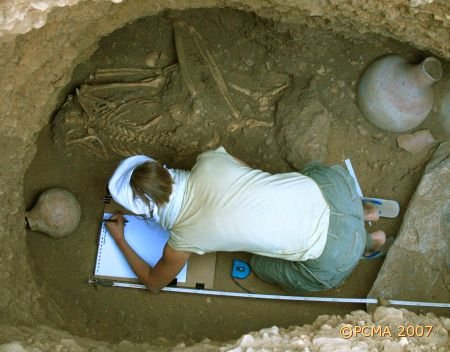
The easternmost of a row of three tumulus graveyards, Shemkhiya 5 lies in a flat plain just west of El-Ar rock. It is dominated by tumulus T19, which is 20m in diameter. Altogether six mounds were explored in February and March 2006, the superstructures featuring both the ovoid type with stone kerb and the oval mound of gravel without stone lining. The skeletons (mostly of women) were found wrapped in what must have been a shroud or bag of leather. Other finds, apart from various pottery jars and bowls, one with an impressed urei frieze, included pottery scoopers, hundreds of beads made of ostrich-eggshell, carnelian and quartz, a copper-alloy ring and a glass pendant with floral decoration. Surprisingly, there appeared to be no food offerings, so abundantly evidenced elsewhere, in the burial niches. The cemetery is likely of Late Meroitic date. The entire cluster of burial grounds should presumably be connected with the settled habitation around El-Ar fortress.
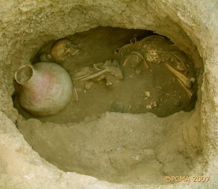
The crucial period of transition from the Postmeroitic horizon to the period of Christian kingdoms in Nubia is illustrated by the excavations in cemeteries located inland from the Shemkhiya fortress (SH8), that is, sites SH9 and SH10. The first of the burial grounds lies at the foot of the gebel, 350m east of the rocky outcrop on which the stronghold sits. Investigation of a few of the typical box-graves, which form 4 or 5 evident groups in this burial ground, unexpectedly revealed a kind of mud-brick platform. More work is planned to help identify the function of this pavement. The adjacent tumulus field of Shemkhiya 10 is so closely interspersed with the Christian box graves that one is left with the impression that the tumuli of Postmeroitic date are the latest pagan internments in the region while the box graves are the sepulchers of Christian converts.

Testing on two settlement sites in the neighborhood of Shemkhiya village provided a rich collection of organic sediments (pollen etc.) from undisturbed stratigraphy. Samples were taken for lab examination.
More surveying work between Shemkhiya and Tanta, carried out by a team headed by Karol Piasecki, identified some 80 rock art and rock gong sites. Altogether 436 representations of animals were registered, the overwhelming majority being images of camels, longhorn cattle, ostriches, giraffes, mounted or led horses. Crosses were frequent as well, suggesting a Christian origin of the petroglyphs in many cases. Twice the team found the quartzite pounders that the artists had used to make their drawings abandoned on the ledge below the pictures. Tumuli fields and settlement sites were also recorded.
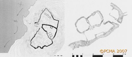
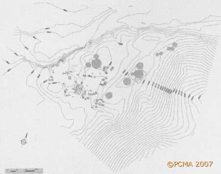
The mapping section of the expedition concentrated on completing plans of the fortresses in Shemkhiya (SH8), El Ar (SH1) and the fortified complex on the island of Tanta, apart from preparing standard contour maps of all sites under excavation.