Alexandria: Kom el-Dikka (Egypt)
Archaeological excavations and conservation and restoration works: the 2007/2008 season
Dates: 1 September 2007 – 31 May 2008
Team:
Dr. Grzegorz Majcherek, archaeologist, director (PCMA)
Renata Kucharczyk, archaeologist and glass specialist, deputy director (PCMA)
Emanuela Kulicka, archaeologist (freelance)
Iwona Zych, archaeologist (PCMA)
Adam Jegliński, archaeologist (PCMA)
Szymon Maślak, archaeologist (PCMA scholarship holder)
Robert Mahler, anthropologist (PCMA)
Ewa Czyżewska, documentalist (PCMA)
Kalina Juszczyk, documentalist (PCMA scholarship holder)
Dr. Wojciech Kołątaj, architect (emeritus)
Daria Tarara, architect (freelance)
Aleksandra Brzozowska, architect (Wrocław University of Technology, PhD candidate)
Aureliusz Pisarzewski, architect (freelance)
Prof. Barbara Lichocka, numismatist (Research Center for Mediterranean Archaeology, Polish Academy of Sciences)
Joanna Lis, conservator (National Museum in Warsaw)
Adam Zieliński, conservator (Royal Ontario Museum)
Władysław Weker, conservator (State Archaeological Museum, Warsaw)
Piotr Musiela, student of archaeology
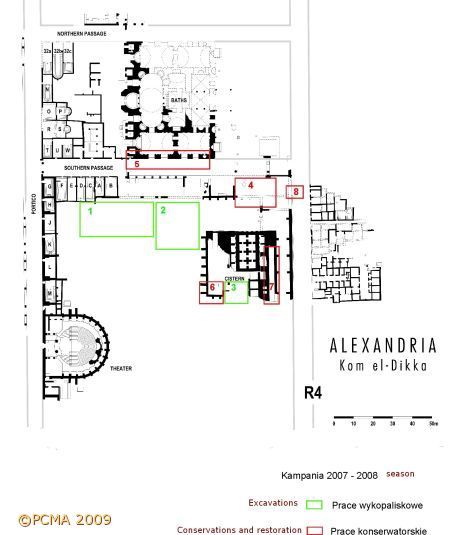
As in the past few years the Polish-Egyptian archaeological and restoration team has focused on completing the site presentation project, which will result in a permanent display of the major ruins discovered on Kom el-Dikka in the fifty years of Polish excavations there (see plan). As this is the only such monumental zone in all of Alexandria (already looming large on the tourist landscape of Alexandria), the project is thus understandably a top priority with the Egyptian authorities, both the Supreme Council of Antiquities and the municipal government.
Much of the site landscaping arrangements has already been accomplished in past years, but there still remains the very center of the site, which has not been explored so far. Huge amounts of soil have to be trucked out — it should be recalled that there had once been a Napoleonic fort located at the top of a huge artificial mound of earth in the center of the site — and this is a logistically difficult and expensive undertaking. In past years, all the modern soil accumulations have been removed, as well as the layer of the Islamic cemetery which had topped the ancient mound in medieval times. This has opened an area of more than 2500 m2 to regular excavations. Needless to say, the very location of the trenches at the center of the site has turned the work into an unintended tourist attraction. It has also necessitated by the same the regular removal of archaeological dumps — this season about 5000 m3 of soil were trucked out again.
Excavations
In the northern end of the excavated area (Sector H) the exploration of the Islamic burial ground from the 11th-12th century was completed (Area 1 on the plan). The anthropologist worked together with the excavators, studying the burials and the human skeletal material on a running basis. The recent work has gone a long way to completing the archaeological explorations of the Islamic graveyards on Kom el-Dikka. Most of the tombs from the three successive levels of this cemetery have now been excavated and removed. The next stage with regard to the richly documented material from the Islamic graves is an intensive study period, which should result in a comprehensive publication.
The key interest of the excavations has thus shifted to the Roman residential architecture of the 1st through 3rd centuries AD, which is being uncovered in Sector F (Area 2 on the plan). These remains are hidden under more than 7 m of an ancient ashes-and-rubbish dump from the baths, which had accumulated over the standing ruins in Late Roman times, that is, from the 4th to the 7th centuries [Fig. 1].
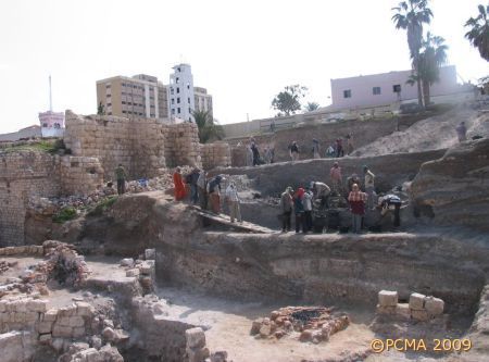
Extension of the trenches to the west and south has now opened an area 40 by 30 m. Exploration of these rubbish deposits yielded the usual array of finds: pottery, lamps, coins and glass vessels. The assemblage is not only a telling reflection on what happened to the surrounding buildings, the rubble from which was deposited here, but it also provides insight into the nature of the functioning of this specific district at the time in question.
Another two lime kilns were uncovered at the southern end of the excavated trenches. The surrounding deposits were characterized by an exceedingly high content of broken marble fragments (elements of architectural decoration, inscriptions, etc.) used for lime production. There can be no doubt that this area had constituted a vast construction site serving the purposes of the huge public building project comprising an imperial bathhouse and cistern complex, undertaken by the city authorities in the mid 4th century AD.
The architecture discovered under this layer connected with the Late Roman buildings belongs to an earlier residential phase. The ruins are a continuation of House FB which started to be explored in the 1990s. At the time, the 10-11 m high deposits rising at the center of the site had placed effective limits on the extent of the explorations. The current work has cleared the western wing of the structure [Fig. 2].
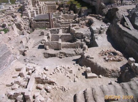
The poor state of preservation is due to several factors: the original quake-related destruction and the operation in and on top of the ruins of the later lime kilns. The house had stood on a side street cutting across this quarter of the town. Thanks to the discovery of this street, it has proved possible to reconstruct a previously unknown part of ancient Alexandria’s street network.
Further exploration of the cistern was also carried out (Area 3 on the plan). Another two water reservoirs of red brick from the original phase of use in the 4th-5th century AD were uncovered. Following detailed analysis of the stratigraphic relations and the combined results of excavations in this area, the building history of the complex has now been fully reconstructed, confirming a series of major rebuilding and restoration projects following in the wake of destruction caused by successive earthquakes.
Conservation and restoration
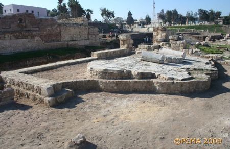
Conservation and restoration works are geared to the scope and timing of successive stages in implementing the Archaeological Park site presentation project approved by the Supreme Council of Antiquities of Egypt. Presently, the work is focused on the Roman Bath complex, where the biggest operation since the previous season has been the reconstruction of the southern outer wall (Area 4 on the plan). This project has now been completed [Fig. 3],
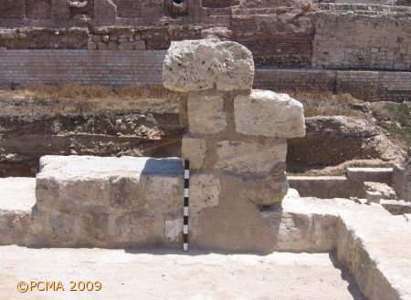
as was also the restoration of the ancient wall remains and pavement in the neighboring apodyterium. A supporting casing wall was erected all around this area [Fig. 4].
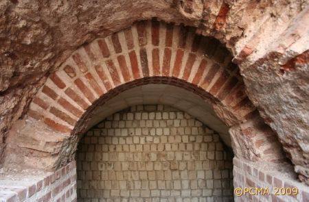
The entire southern facade of the Roman Bath (about 60 m in length) also underwent a conservation and restoration facelift (Area 5 on the plan). All the destroyed parts of the brick wall were rebuilt in brick up to a height of from 1.20 to 2.00 m above the walking level of the paving in the southern passage. The vaults of the brick arches to the hypocaust furnaces in the underground service area in this part of the bath were also returned to their original form [Fig. 5].
Extensive conservation and reconstruction works were needed in the complex of the cisterns. Eight meters of running wall were reconstructed in the southern part of the building, together with the adjoining buttresses (Area 6 on the plan). The southern wall, already partly reconstructed in the 1990s, was now raised another 1.20 m in order to complete the landscaping of the framing slope in this part of the site. The conservation of a huge staircase leading to the top of the cistern complex in the eastern part of the building was also completed (Area 7 on the plan).
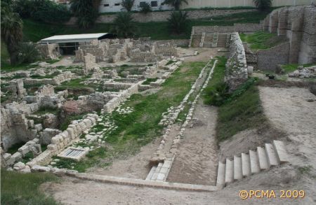
Finally, for the purposes of the tourist walkway which will lead around the site in the future, a set of steps was installed between the habitation district along Street R4 and the Roman Bath complex (Area 8 on the plan; at right bottom in Fig. 6).
[Text based on report by G. Majcherek]
