Al-Subiyah (Kuwait)

Sixth season of work in As-Sabbiya, Kuwait
Dates: March 3 – April 20, 2011
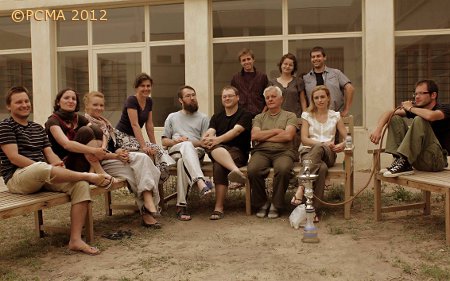
Polish team:
Dr. Łukasz Rutkowski, field director (PCMA)
Dr. Franciszek Pawlicki, archaeologist (PCMA)
Ewelina Mizak, doctoral student in Assyriology (University of Warsaw)
Maciej Makowski, archaeologist, doctoral student in archaeology (Polish Academy of Sciences)
Agnieszka Niemirka, archaeologist (National Heritage Board of Poland)
Katarzyna Hryniewicka, archaeologist, archaeozoologist (freelance)
Piotr Zakrzewski, archaeologist, topographer (freelance)
Maciej Marciniak, archaeologist (freelance)
Dr. Arkadiusz Sołtysiak, anthropologist (University of Warsaw)
Barbara Górak, archaeologist, publishing/graphic specialist (freelance)
Master’s students of archaeology: Ireneusz Nazaruk, Olga Sabala (University of Warsaw)
Kuwaiti team:
Sultan Ad-Duweish, head of the team
Khaled Salem, Talal Abdullah Shameri and Faisal Al-Uteybi, archaeologists and archaeological team support
The spring season of the PCMA expedition excavating (for the sixth time in a row) archaeological sites in the As-Sabbiya region at the invitation of the Kuwaiti National Council for Culture, Arts and Letters (NCCAL) was focused on three projects: 1) tumuli graves and other stone structures on the As-Sabbiya plateau, 2) well sites, and 3) extensive survey of the region (continued from 2009).
During the season, 15 archeological sites were explored, including six tumuli graves, four so-called elongated structures, three small stone features, one extensive site consisting of stone spreads and shell middens and one well complex. Fieldwork at the well complex encompassed nine different features: two wells, two structures comprising lines of stones (pavement and hut/camp foundations) and five test trenches. Excavations were carried out at four different locations (Bahra, Dubaij, “Dubaij-East”, Ras As-Sabbiya) within a territory, the extent of which between the farthest points was 14.5 km in a straight line.
Concentration of stone structures in the Bahra area. Second season of exploration
Stone mounds
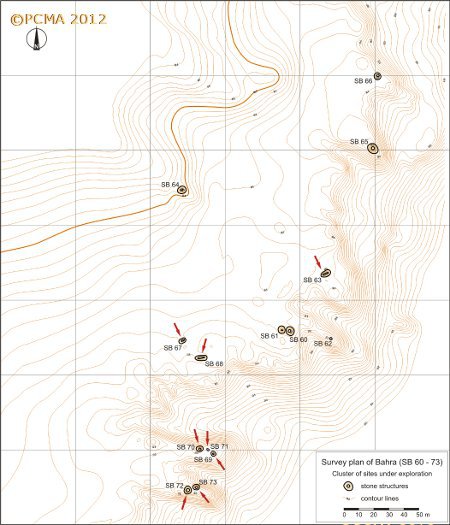
This season saw the exploration of another four tumuli graves, one likely burial structure, and three elongated structures, located to the generally west (with the exception of one) of the five structures excavated in this area previously (see PCMA Newsletter 2010).
The tumuli graves stood in pairs on two narrow promontories projecting from the main rock massif in the southwestern part of the excavated zone: SB 69 and SB 70 on the northern of the two with a small flat structure SB 71 located between them and SB 72 and SB 73 on the southern one. The latter two were situated about 2.50 m apart, while the former stood 10 m from one another.
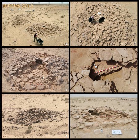
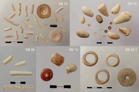
SB 69 was a heavily deteriorated oval mound, low and flattened, constructed of medium-sized stones. It measured 3.80 m by 4.50 m and was 0.50 m high. Instead of a regular chamber, as in the majority of excavated structures of this kind, there was an ovoid ring of large stones outlining an inner space (3.60 m by 2.30 m), which was tightly packed with medium-sized stones. Three tusk shell beads were turned up during exploration of the middle part of the structure. Burial function was suggested by a few tiny bone fragments (which could not be identified), found in the upper part of the stone coating. The other tumulus in this pair, SB 70, was a middle-sized, oval stone mound (5.25 m by 5.85 m, 0.75 m high), standing directly on the bedrock shelf. It had been initially a regular circle in plan, but part of the mantle has now tumbled down the slope. Indeed, the jumbled stones on top and the partly uncovered grave chamber indicate that the grave had been penetrated in the past. A sizable, almost circular (1.10-1.15 m in diameter) grave chamber was found at the centre of the mound. It was formed of five to seven layers of large and well fitted slabs. The loose sand which filled this chamber in its entirety produced nine beads: two beads of stone (most likely carnelian), five small, simple disk-shaped beads of shell, one cylinder-shaped bead of shell, and one bead of frit(?), as well as seven shells. There were no skeletal remains.
The flat and very low structure lying between the tumuli, SB 71, was of ovoid shape (3.90 m by 3 m, 0.20 m high). Two courses of fairly large and well fitted flat slabs formed an ovoid ring with an oblong empty space in the middle (0.80 m by 1.30 m), possibly prepared for a grave chamber. Taking into account the similarity between its outline and the inner frame of tumulus SB 69, it would make this a kind of tumulus base-plan, delimited by a single layer of stones. The structure produced no finds.

The largest of the stone mounds excavated this season, SB 72, was erected on a sub-circular plan (6.70 by 7.20 m, 1 m high). The ancient builders seem to have taken advantage of a jutting ridge of bedrock to erect this tumulus. The structure had a sizeable, flattened top constructed of horizontally laid slabs. A long elliptical grave chamber (0.60 m by 1.05 m) widened toward the bottom, which was found 0.60 m down from the top. A long narrow gap in the chamber bottom may have been cut by robbers searching for treasure. The fill produced 25 beads, including 21 tusk shells, two ring-shaped white-shell beads, one small bead made of stone (carnelian?) and one bead made of a plastic material, perhaps frit or bitumen(?). Similarly as in the case of tumulus SMQ 30 (excavated by the Polish team in 2007-2008), eleven of the beads were turned up not in the grave chamber, but among the stones of the coating. Only a few tiny fragments of bones (impossible to identify) were found inside the chamber.
The other tumulus in this pair, SB 73, was an oval stone mound (5.90 m by 4.20 m, approximately 0.60 m high) situated at the very edge of the ridge. This resulted in the northern part of the mantle tumbling down the gully. The oval grave chamber (0.95 m by 0.50 m at the top) widened toward the bottom on one side (0.77 m at the bottom) and had a hollow hewn in bedrock at the center. SB 73 had one peculiar feature: a single large slab facing east and angled out (a kind of directional marker?) in the outer perimeter of the mantle. Only three personal ornaments were found inside the chamber: two beads of carnelian (very similar to one another in size and shape) and a single small Conus shell bead. Several dozens of severely deteriorated bone fragments from the chamber could not be identified.
The same general location of the tumuli and the similar nature of the grave goods could indicate that the structures were roughly contemporary, but precise dating remains an open issue for lack of datable criteria. The burial mounds demonstrate differences in the construction technique, such as details of the shape of the chamber, its depth and alignment of stones in the mantle. An early date is suggested by the simple form of personal adornments, which can be found also in Late Neolithic settlement sites in the vicinity (Bahra 1, H3). On the other hand, there are some indications pointing to the Early Bronze Age as the date of the site.
Long stone structures
Long stone structures are the second most conspicuous archaeological feature in the As-Sabbiya region. These relatively narrow and elongated stone features have an oblong outline, which gives them the appearance of long, flat platforms. They are situated frequently in the vicinity of tumuli graves, which suggests there was an association of some kind between the graves and these mysterious structures. Excavations so far (SMQ 36 and SMQ 37 in the Mugheira region investigated in 2008, see PCMA Newsletter 2008) have produced extensive data on the manner of construction, but no finds of any kind. Their function therefore remains obscure. Even so, a ritual character seems to be the most plausible.
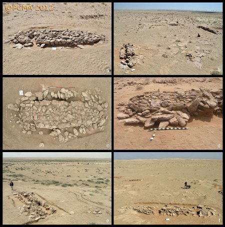
In the Bahra area the team now excavated three such features (SB 63, SB 67, SB 68). Unlike the burial mounds which were located on the edge of the natural rock terrace, the elongated structures stood in a flat terrain 20 to 40 meters away from the plateau edge: SB 67 and SB 68 approximately 20 m apart, SB 63 isolated, about 100 m to the northwest of the first two. The fourth structure of this type was explored in the region of “Dubaij-East”.
The present discoveries have led to a revised understanding of the height of these structures. They had been believed to be low, but were now proved to be as high as most tumuli graves or even higher than some of the smaller ones. SB 68 was 0.70 m high with a length of 10.30 m and a width of approximately 1.70 m; respectively, SB 43 was 0.60 m and 10.50 m by about 2 m; SB 63, 0.60 m and 9.70 m by 2.50 m; and SB 67, 0.50 m and 6.30 m by 1.90 m.
All the structures of this type excavated this season were built of several layers of large, tightly fitted horizontal slabs (up to seven layers in the highest part of SB 68). The height of the structures and the number of stone layers gradually decreased toward the shorter ends. The edges of the structures were lined with large slabs (up to 0.80 m high and 1.15 m long) set up on end. They were partly dug into the ground and kept in place by slabs leaning against them from the outside, additionally secured with small, flat stones tightly packed in on either side. A casing of this kind occurred along the entire perimeter of SB 63 and SB 43, while SB 67 and SB 68 were bordered only around one of the shorter ends (up to one-third of their length). Another peculiar feature of the long structures is that their shorter sides were always rounded (usually one end had rounded corners and the other was curved). SB 63 and SB 43 bore traces of destruction (most likely robber’s pits).
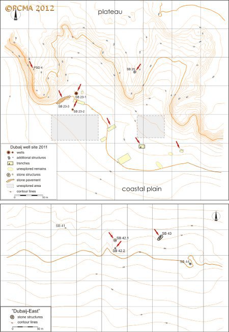
Dubaij well site. Second season of exploration
The huge, oval well-cistern SB 23-1 was excavated down to bedrock and fully documented this season. It was 3.05 m by 3.70 m in diameter (inner dimensions measured at the mouth). The well sides were constructed of some 23 layers of undressed and unbonded stones laid in tight rows, built not on bedrock, but on a layer of clay 0.25-0.35 m thick. The total well depth was thus approximately 3.70 m (and about 4.30 m, if the height of the curb above ground is included).
Limited, but important investigations were conducted in a small well SB 23-2, which was dug in the vicinity of the well-cistern. Its diameter at the mouth measured approx. 1.25 m and its stone curb consisted of 12 regular layers (approximately 1.55 m high) of limestone and sandstone blocks set without mortar. The oval shaft, approximately 0.70 m at the widest, was hollowed out in rock, slightly over one meter down, ending in a solid bottom, The total depth was 2.75 m. Two fissures, were found by the bottom of the shaft, leading sideways, presumably to underground water pockets. One of the fissures leads towards the well-cistern SB 23-1 and may have connected it with the smaller well. This discovery may suggest that the two structures (SB 23-1 and SB 23-2) may have functioned together as part of one complex, presumably according to the principle of communicating vessels.
Excavations carried out directly to the west of a low-roofed concrete emplacement (SB 23-1B), located a few meters west of the well-cistern, resulted in the discovery of a 23.50 m long stone paving (SB 23-3). Its width was not uniform, but in the best preserved segment it measured 3.55 m. The structure proved to be composed of a single layer of flat stones, set without mortar. The northern part was almost perfectly even. The function of the structure is unclear. It should be regarded as a stone pathway, roughly aligned SW-NE, and leading directly to the well-cistern. However, it is unknown why this particular fragment of desert track would have been strengthened in this way. The foundations of SB 23-1B cut through this paving, indicating that the emplacement was a later installation.
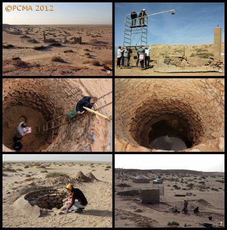
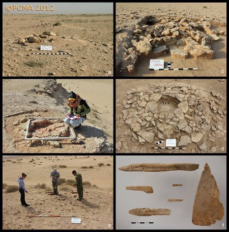
Stone structures on the plateau of Dubaij
Two small structures were excavated on the edge of the cliff above the Dubaij well site. SB 20, a small stone mound of sub-circular shape (3.35-3.75 m in diameter, and 0.30 m in height), proved to be constructed of two regular rings of stones. The inner one encircled a circular grave chamber (approximately 0.85 m in diameter). PSD 4, a very small circular stone feature, consisted of a single layer of stones lying directly on solid bedrock. The stones were arranged in a regular ring (1.10 m in diameter, 0.07 m in height). The function of the structure is unknown (bottommost part of a deteriorated cairn?). SB 20 and PSD 4 yielded no finds.
Three stone structures were excavated in Dubaij-East, an area where the Dubaij plateau becomes gradually lower and merges into a sandy coastal plain, about 1300 m to the east of the well site. SB 42.1, a small stone mound with sub-circular plan (3.75 m by 4.30 m, 0.40 m in height) consisted of two concentric rings of stones (the inner ring is 1.50 m in diameter). However, as in the case of SB 69, there were no clear remains of a grave chamber and exploration did not yield any human bones. The centre of the mound was filled with tightly packed, medium-sized stones, some of which were partly overlapped by slabs of the inner ring. Three rings made of Conus shell and several dozens of broken shells of the same family were found within the sand cover and between the stones inside the structure. It cannot be excluded that these shell rings were produced in the immediate vicinity of the tumulus and the broken shells are the remains of a small provisional workshop (a large concentration of shells was traced inside an adjacent structure, SB 42.2, which was a pile of loose stones). SB 42.1 also produced a recut, pierced pottery disc – the first pottery find ever discovered by our team inside a tumulus-like structure. The sherd is of the common ware, light yellowish-beige slipped. At first sight, it looks similar to some of the sherds picked up during the survey and dated to the Parthian-Early Islamic period. In view of this SB 42.1 has proved difficult to compare with other mounds. SB 43, an elongated structure (see the section on long structures above) is situated approximately 90 m to the east of SB 42.1-2.
Archaeological survey
The easternmost part of the As-Sabbiya region, that is, Dubaij East and Ras As-Sabbiya subregions, was surveyed this season, the prospection covering approximately 14.50 square kilometers and identifying 35 new features.
Few stone mounds were recorded this year in contrast to previous seasons. Apart from uncertain features or ones that are difficult to identify, there were some remnants of temporary camps, a number of small, flat, linear stone alignments, several stone spreads and several scatters of potsherds and shell middens. The latter two categories are located in the flat terrain on the coastal plain, close to the presumed former coastline.
The extensive site RS 8, located nearly 3 km to the southeast of the well site, was considered promising but three test trenches dug at the end of the season did not confirm the presence of an ancient settlement of substance. Only one trench revealed a man-made stone feature on the site.
Other activities
Anthropologist Arkadiusz Sołtysiak examined the human skeletal remains from graves excavated in the 2009-2010 seasons. The large collection of bones from a multiple burial in tumulus SMQ 49 proved to represent 17 individuals, including five tentative adult females, four tentative adult males, four adult individuals with no sex assessment possible, one adolescent and three children. Proper cleaning of the bones revealed a collection of seven artifacts made of animal bone and a few bone fragments showing intentional cut marks. The collection comprises simple tools and adornments, including pointed implements, a cylinder-shaped bead and a pendant in the form of a perforated triangular plaque.
The archaeozoological analysis of faunal remains from SMQ 49, carried out by Katarzyna Hryniewicka, identified the remains of an equid, probably an onager, buried in the grave as a whole. SMQ 49 is thus the first grave in Kuwait to contain scientifically confirmed evidence of this species. The grave produced also some remains of goat/sheep and birds; since only select parts of the skeleton were identified, it could suggest burial of cuts of meat of consumption value, hence proof of symbolic meals being offered to the dead.
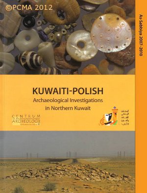
Plans for publishing a booklet on the joint Kuwaiti-Polish archaeological investigations in Northern Kuwait (2007-2010), agreed upon beforehand with our Kuwaiti partners, were carried out during the season. Barbara Górak, an archaeologist and graphic designer, prepared the publication, which the NCCAL issued a few months later.
[Text: Ł. Rutkowski]
