Selib (Sudan)
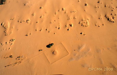
Selib (which means „cross” in Arabic) was located during a Canadian survey in 1984 of the Nile Valley between El-Chandak and Debra, on the right bank, upriver 9 km from Banganarti and 20 km from Dongola. In 1998, the SDRS Survey project directed by Bogdan Żurawski confirmed earlier information from the Sudan Antiquities Service files and the Canadian mission’s survey about archaeological sites in the neighborhood of the village, now completely covered by wandering dunes. Aerial and kite photographs showed the location of the murabba kebir or „great rectangle”, as the natives call the place. In 2007, a geophysical team – Tomasz Herbich from the Polish Academy of Sciences (IAE PAN) and Dawid Święch – took time off from the main work at Banganarti to map this enclosure.
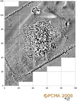
Bogdan Żurawski (Polish Academy of Sciences), who is in charge of this work, had been sure that the huge quantities of brick debris and crumbled lime mortar were traces of a ruined church. The geomagnetic prospection did not give a clear view of the wall layout precisely because of the amounts of brick, but they revealed a mysterious round feature measuring 8 m across to the east of the main building inside the rectangular enclosure. Round structures in Nubia are usually furnaces, but never this big and indeed the round tomb in Soba south of Khartoum is the only architectural structure on this plan known from this region.


Testing on the spot of the round feature revealed a structure of red brick. Another trial pit excavated in the eastern side of the mound in the center uncovered architectural remains which coupled with a stone reliquary, oil lamps and small column possibly from an altar screen left no doubt as to the sacral function of the building. While at this stage of the research, no details are available, it is possible that the structure stands on a platform of some kind, possibly the leveled ruins of an earlier architectural complex.
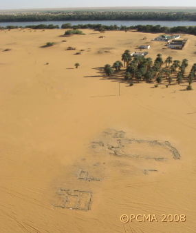
Checking out information from local residents, the mission surveyed a site located just a kilometer away from the church enclosure. The ruins had come to light under the wheels of passing trucks once the wandering dune here had moved on in the direction of the Nile. The whole area is strewn with fine quality pottery, including the thin-walled stamped ‚eggshell’ ware, which the mission’s ceramologist Dobiesława Bagińska immediately identified as Meroitic from the 1st/2nd century AD. Clearing of the tops of walls revealed a huge architectural complex (c. 900 square meters) surrounded by private houses. More than a kilometer of land along the old Nile bed is scattered with pottery, indicating that Selib must have been an important center, possibly the seat of a Meroitic governor or local ruler. This in a part of Nubia that researchers have hitherto considered as being outside the sphere of influence of the kings of Meroe. It is believed that the region was under the rule of a tribal group which retained a large measure of independence from the central authorities. Since, however, the Meroites must have used the desert shortcuts between Napata and Nubia, it now seems that their cultural, if not political and administrative influence in the neighborhood of Selib was quite overwhelming.
Meroitic palace structures are known from Faras, Wad ben Naga, Karanog, Jebel Barkal and the Royal City of Meroe. Houses of this date have been investigated at Ash Shaukan and Naga in respectively Lower and Upper Nubia, as well as earlier at Wadi el-Arab in Lower Nubia.


