Tell el-Ghaba (Egypt)
Tell el-Ghaba geophysical survey, 2010
Dates: 30 April – 10 May 2010
Team:
Tomasz Herbich, project head (Institute of Archaeology and Ethnology, Polish Academy of Sciences)
Dawid Święch, Robert Ryndziewicz and Krzysztof Kiersnowski (freelance
Tell el-Ghaba was one of the sites on the ancient “Way of Horus”, the land bridge between the eastern Nile Delta and the Levant. It is located at 30° 58’ North and 32° 25’ East, between Tell Hebua to the west and Tell Kedua to the east, at the edge of the eastern part of a lagoon, near the former Pelusiac branch of the Nile. The Argentinian Archaeological Mission undertook research at Tell el-Ghaba in 1995 as part of a salvage project under the auspices of UNESCO, aimed at investigating the antiquities of northern Sinai threatened by advanced irrigation works in the region. The archaeological exploration in 1995-2002 led to the identification of an early Saite settlement, dated to the early Twenty-sixth Dynasty (pottery dates point to the reigns of Psamtik I and Psamtik II).
Returning to the site after eight years, when the project was temporarily suspended, Argentinian Mission director Sylvia Lupo opted for repeating geophysical research in an effort to enhance the magnetic images obtained for part of the site during the original magnetic survey carried out in 1998-1999 by Jorge Trench. The present survey is being carried out within the framework of an agreement for cooperation between the Polish Centre of Mediterranean Archaeology and the Instituto Multidisciplinario de Historia y Ciencias Humanas, Consejo Nacional de Investigationes Cientifícas y Técnicas in Buenos Aires.
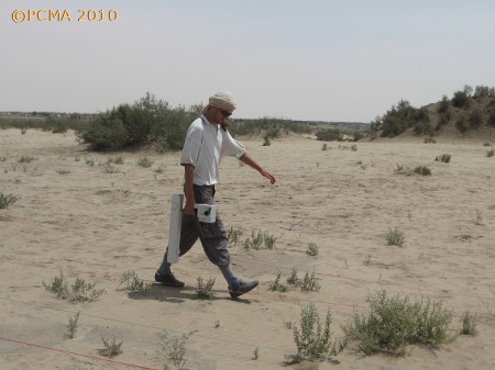
The architecture lies no deeper than 1.80 m below ground surface and only the basement of the mud-brick structures remains. The overall site surface has been calculated at approximately 12 ha. The original measurements covered 1.6 ha and were carried out in a grid 0.5 by 1m (2 measurements per square meter) or 0.5 by 0.5 m (4 measurements per square meter), in parallel mode. The survey in 2010 was carried out with two fluxgate type gradiometers measuring the vertical component of the magnetic field with up to 0.1 nT accuracy. Measurements were taken along lines spaced 0.5 m, every 0.25 m, within a 20-m grid, in parallel mode. The total area covered by the mapping this season was 6.56 ha.

Magnetic survey in 2010: results
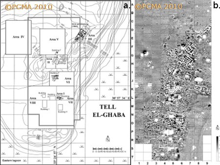
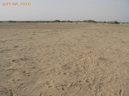
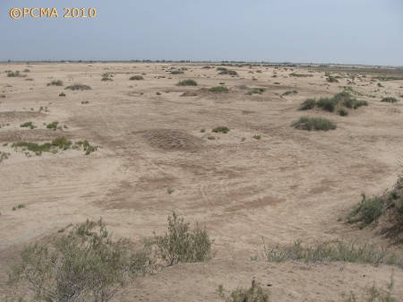
The prospection was carried out in a rectangle 180 m wide and 380 m long in the central and eastern part of the site [Fig. 1]. In the northern part of the area this is mostly flat ground, in the southern part there are small mounds, usually no more than several dozen square meters, covered with vegetation [Figs 2 and 3], the eastern border rises to about 2 m in height. No traces of architecture of any kind can be observed on the surface. Archaeological dumps and military embankments can also be seen in places.


The map demonstrates a belt of anomalies distinguished from a less disturbed surrounding [Fig. 1]. This belt is about 100 m wide at the southern end and narrows toward the north. It reflects architecture of heterogeneous but still approximately the same orientation, aligned NNE-SSW/SEE-NWW. Walls have shown up mostly as negative anomalies; positive anomalies occurred in just a few cases. The building plans are mainly square, as is typical of Saite architecture, the sides reaching up to 20 m in length. Structures identified during previous geophysical research are outlined quite clearly.
The present magnetic survey has traced the western border of architecture in squares R2 in the south, through G5 and on to D9 in the northeast. The eastern border of the ancient architecture runs from T5 to L8, where it turns a right angle and continues in an eastward direction. The narrowing of the belt of anomalies corresponding to settlement architecture, observed north of squares J8 and J9, appears to be due to a thicker layer of overlying sand concealing the remains. Wherever the ground dips in this area, that is, the overlying deposits are thinner — as in K8 and K9 — traces of architecture have been mapped distinctly. Anomalies reflecting architecture are present also in the area with lower distinctness of the magnetic image, e.g., squares I8 and G8. The settlement appears to have lined the shore of a lagoon, which is reflected by an anomaly curving slightly from the center of T8 to the southeastern part of N9. It would appear that in the southern part of the surveyed area the architecture was located some 40 m away from the shore.
A series of anomalies of oval shape and diameter from 1 to 2 m, characterized by high-amplitude values, was mapped in squares E8, around the joining of G5 and G6, J8, by the western border of K7, in N3 and N4, at the northern end of P6, in R4. Some of these (as in E8, J8, P6, N3) were mapped in sections of the map reflecting architectural remains. These anomalies should be interpreted as images of furnaces or open hearths.
Anomalies of irregular outline, characterized by raised magnetic field intensity values, run along the western border of the settlement (for example, in squares C7-E7, E5-J5). They are thought to correspond to concentrations of mud or ashes. Those of more regular shape could reflect the fill of pits of some kind.
The unsurveyed areas on the present map correspond to mounds covered with vegetation or archaeological dumps from the earlier excavations.

Conclusions
The results of geophysical research in Tell el-Ghaba confirm yet again the usefulness of the magnetic method when properly applied in reconstructing the layouts of architecture raised of Nile-silt brick.
The existing tentative plan of the settlement proposed in effect of a ground survey of site will now require revision once the magnetic mapping results are taken into consideration. The magnetic prospection shows beyond all doubt that architectural remains can be found in a belt approximately 100 m wide lining the eastern shore of a lagoon. Area V, which is located about 150 m from the shore of the lagoon and which was believed to be part of the settlement based on the abundant scattering of ceramics on the surface, appears to be devoid of any architectural substance, judging by the magnetic results. The survey has also excluded the presence of any kind of architecture in area IV (at least at the eastern edge which was covered by the present prospection).
Acknowledgments
Special thanks to Giorgio Nogara of the Tell Herr mission in Sinai for his invaluable assistance in the course of the survey.
[Text: T. Herbich]
