Berenike 2007/2008
In the winter of 2007/2008 the University of Delaware (USA) returned to the entrepôt of Berenike on the Red Sea in partnership with the Polish Centre of Mediterranean Archaeology, University of Warsaw (Poland). For reasons beyond the excavators’ control, the first season after a six years’ break (the site was explored previously in 1994-2001) covered only a short geophysical prospection, originally planned as part of the program for the season.
The work was carried out on March 1-7, 2008, by geophysicist-archaeologist Dawid Święch, working under the supervision of Tomasz Herbich and assisted in the field by Robert Mahler. The expedition’s director, Steve Sidebotham, could not be present at the time, so he left the work in charge of co-director Iwona Zych from the PCMA
Explorations in and around the Ptolemaic-Roman port of Berenike (located approximately 825 km south of Suez and 260 km east of Aswan) had uncovered the Roman-age town and port, as well as evidence of extensive activity at the site during the Ptolemaic period. The peak periods of Berenike’s long distance trade were in early Roman (1st century AD) and late Roman (mid-4th to 5th centuries AD) times, but so far little has been turned up for the town’s commercial contacts in the earliest period (3rd-1st centuries BC).
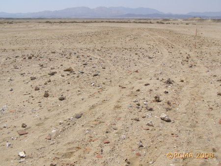
A study of the topography by the Project’s geologist James Harrell had led the team in previous years to suggest a location for the Ptolemaic harbor on and around a crescent-like feature with spoke-like tongues of higher ground stretching into a dry wadi to the south. The ridge and the higher ground are rich in surface archaeological material in the form of sherds, coral heads, stones, shells big and small, and coral debris.
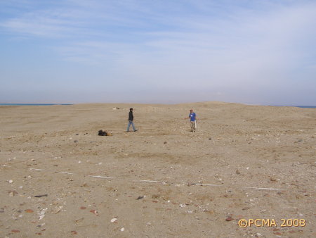

The geomagnetic prospection was carried out with a Geoscan Research fluxgate gradientometer FM 256 with 0.1 nT resolution and 0.1 second measuring time. The survey grid measured 0.5 by 0.125 m (along measurement lines 0.5 m apart, every 0.125 m on each line) within squares 20 by 20 m. Measurements were taken in zigzag mode (registering measurements while carrying the instrument there and back) and correcting the position of the probes after each square. The research covered a total area of 2 ares. Preliminary processing of the survey results was done with Geoplot 3.0 software by Geoscan Research. The prospection covered most of the crescent-like ridge curving from northeast to southwest across the site and the area inside this crescent reaching the flat ground beyond the ridge and to the west of it.
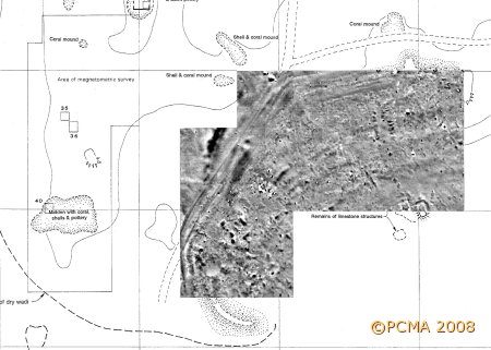
Preliminary plotting of the results have revealed a structure of some kind following the line of the crescent-shaped ridge and possibly turning inside from it, as well as two strong anomalies paralleling this structure in the northwestern corner, on either side of it. Also, limestone structures at the southernmost end of the site are now clearly traceable. A series of anomalies running parallel across the center of the surveyed area correspond to patches of brown earth with burning (iron ?) noted during fieldwalking of the area. Archaeological testing of the area is planned for the coming season.
For seasons between 1994 and 2001 by the University of Delaware (USA) and Leiden University (the Netherlands), see
http://www.archbase.com/berenike/english1.html